Articles

Birding the (nature-altered) Beaver Creek Nature Area

White-throated Sparrow - Zonotrichia albicollis

There are two parks near our house that are characterized by heavily wooded lands next to a river. The first is the Big Sioux Recreation Area, just across the street. It’s nice, but it’s the far more developed of the two parks. This time of year I admit I’m not fond of birding there. They cater SO heavily to campers, going in and taking out a lot of the vegetation around the campsites to accommodate space for the giant RVs that are now so prevalent. I did go there last night for about 20 minutes, before the noise of the big-screen TVs blasting gameshows at top volume drove me away. I REALLY don’t get the point of people who do that.

The second park is Beaver Creek Nature Area. It’s about 3 miles from my house, and is MUCH less developed. No camping…yes! There are trails winding along riparian areas, upland woodland, and open grassy areas. Without the camping, it gets much less attention and is far less crowded. From a birding perspective, it’s wonderful. You can HEAR THE BIRDS! No TVs!! No loud campers! Just…nature.

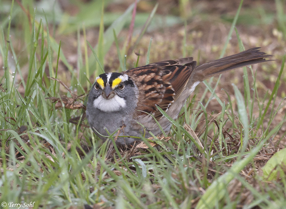
I had a couple of hours this morning and headed to Beaver Creek. It was an incredibly foggy morning, but the park was certainly birdy. Migrant warblers still have yet to move through in any numbers, and for the morning I didn’t see a single warbler species. That’s a bit odd, as usually you’d at least see plenty of Yellow-rumped Warblers moving through. But what it lacked in warblers it made up for in sparrow species. White-throated, Harris’s, Clay-colored, Chipping, Lincoln’s, Swamp, White-crowned, and Field Sparrows…not a bad mix for one spot, and I frankly I get just as excited for all the migrant sparrows as I do the warblers. Other first-of-year sightings included Rose-breasted Grosbeaks, Northern Rough-winged Swallow, and Yellow-bellied Sapsucker.

Before heading that way for the first time this spring, I admit I was a little concerned about what condition the park would be in. With near-record flooding this spring, one road to the park is closed, and there’s still plenty of high water around. I was happy to see the park open and most of the trails accessible, but there was one major change in the park…Beaver Creek changed course! Over the last couple of years, one big loop in the creek was eroding away the bank just as you crossed a little pedestrian arch bridge over the creek. That’s not going to be a problem any more! Further upstream a bit, the flooded creek evidently tore through a narrow strip of heavily wooded land, cutting off the loop. The water was still quite high and a small amount of water was flowing through the loop, but as the water returns to normal levels is pretty clear that loop is now completely cut off and is going to be a new oxbow.

Thankfully it’s not going to affect the trails in the park, but it certainly is a great indication of just how powerful and unpredictable Mother Nature can be! A few photos from this morning:

Yellow-bellied Sapsucker - Sphyrapicus varius
Yellow-bellied Sapsucker, one of the first-of-year sightings from today. One of my favorite bird species, and one that’s usually relatively easy to find at Beaver Creek in the summer.
American Robin - Turdus migratorius
“Just” an American Robin. I say “just” because they’re common and people just seem to overlook them. They’re such a gorgeous bird though, and with a wonderful song that just screams “spring” after a long South Dakota winter.
Beaver Creek Nature Area - South Dakota
Overview showing what happened to the creek. The area between the red lines is where the flooded creek tore through a wooded area and created a new channel, thus cutting off the hatched area, which is now a new oxbow.
Beaver Creek Nature Area
South Dakota
Pic on a foggy morning, showing where the new channel cut through an area of trees and cut off the channel to the right, which now looks like it will be an oxbow that only has flowing water during times of high water.

Eagle Convention at Splitrock Creek

After 17 or so years of using one lens for bird photography (a Canon 400mm 5.6L), I ordered a new lens that arrived Monday…the Canon 100-400mm 4.5/5.6L IS II that I’ve mentioned previously.  The timing was fortuitous, as late this week we’ve had something rather unprecedented happen for the area around our little town. We’ve had severe flooding, flooding which is actually supposed to get worse early next week as all the snow pack north of us melts. Splitrock Creek runs through our little town of Brandon, and in the wake of the flooding it has left massive ice chunks all along banks and roads near the river. But it also left scads of dead Asian Carp and other fish.

Seemingly overnight, the area around our town has been inundated with Bald Eagles. We actually have an active Bald Eagle nest less than a mile from our house, a nest that’s been used continuously for about the last 6-7 years.  It’s not rare to see one or sometimes even two Bald Eagles while out and about near our town. Today however, I was on a bridge over Splitrock Creek, and from that one spot I counted 29 Bald Eagles. In…one…spot.  There have been eagles in varying concentrations all along a 10-mile stretch of Splitrock Creek that I’ve checked out this week.

When I started birding 20 years ago, I still remember seeing my first Bald Eagle along the Big Sioux River near Canton. I remember the excitement of seeing such a majestic bird. It’s amazing how rapidly their numbers have increased in the last few decades, as I can now be in any part of South Dakota, in any season, and it’s not a surprise to see one or more Bald Eagles. Even when I visit the grasslands in the central part of the state, an area that is far from any significant river or lake, I find Bald Eagles, sometimes in big numbers. A true success story for American conservation!  But even on a night like tonight where eagles are seemingly everywhere, it’s still a thrill to see and photograph these birds.  Some photos from today:

Young Bald Eagle - Haliaeetus leucocephalus

Young (3rd year?) Bald Eagle, flying over Splitrock Creek near Corson, South Dakota. However, it’s not just young birds that are in our area right now. In fact, a majority of the Bald Eagles I’ve seen in the last few days have been fully mature birds.

Bald Eagle - Haliaeetus leucocephalus

A mature Bald Eagle flying over the trees near Brandon. There were plenty of mature Bald Eagles around, but they were seemingly shyer than the young birds.

Bald Eagle - Haliaeetus leucocephalus

Another young Bald Eagle sitting on a tree stump northeast of Corson. While most birds are along Splitrock Creek, there are so many birds around that they seem to have spilled out onto the surrounding farmland as well.

Bald Eagle - Haliaeetus leucocephalus

A mature Bald Eagle hanging out on a chunk of ice left behind by the flooding at Splitrock Creek north of Brandon. This is perhaps the most common “perch” for these guys right now, as most of them that I’ve seen have been among the ice flows, where the dead fish are concentrated.

Bald Eagle - Haliaeetus leucocephalus

A long-distance shot, but it gives you an idea of the concentration of the eagles. There are 10 in this one shot, sitting on stranded ice blocks on a sandbar in the receding Splitrock Creek. This is the location where I saw 29 birds at once today.

Bald Eagle - Haliaeetus leucocephalus

An even longer-distance shot, showing a common sight in the trees near Splitrock Creek this week. There are 8 birds in this one tree, but it’s this group of trees where a local farmer told me there were 75 roosting overnight earlier this week.

Silver lining to the flooding – Icy Art

With a snowier winter than I ever remember in my 26 years in South Dakota, and with a couple of inches of rain over the last week, we’ve also had flooding far worse than I ever remember. The number of roads that are closed boggles the mind, while parts of Sioux Falls and the surrounding area where I have NEVER seen flooding are now flooded with several feet of water. Yesterday I went out to take photos of the flooding, and while it was incredible to see, I ended up on a gravel road east of my home town of Brandon, pointing the camera down at the ground. What was it that attracted my attention away from the flooding and flood damage?

As the water has started to retreat, there’s a massive amount of ice that’s being left behind, from massive chunks big enough to block traffic on roads, to very fine ice crystals that formed as temperatures cooled after the main flood event. What caught my attention on this road was an icy shelf of ice and ice crystals, suspended over the road. As the water started to retreat, we had a cold night, and the top of the water started to freeze. With the water movement and retreat and the freezing, some of the patterns left on this suspended ice shelf were incredibly beautiful.

I’m glad I arrived as I did, because as it got warmer, this icy shelf started to collapse. Indeed, as I walk through it, one step would crack through the shelf and lead to the collapse of surrounding areas as well. But with some careful shooting, I was able to capture the photos below. It definitely wasn’t what I was planning on shooting when I went out, but I really had a blast shooting these one-of-a-kind icy patterns.

Ice Pattern - Minnehaha County, South Dakota

Ice Pattern 2 - Minnehaha County, South Dakota

Ice Pattern 3 - Minnehaha County, South Dakota

Ice Pattern 4 - Minnehaha County, South Dakota

Ice Pattern 5 - Minnehaha County, South Dakota

Ice Pattern 6 - Minnehaha County, South Dakota

Ice Pattern 7 - Minnehaha County, South Dakota

Ice Pattern 8 - Minnehaha County, South DakotaIce Pattern - Minnehaha County, South Dakota

Ice Pattern 9 - Minnehaha County, South Dakota

Ice Pattern 10 - Minnehaha County, South Dakota

Ice Pattern 11 - Minnehaha County, South Dakota

Ice Pattern 12 - Minnehaha County, South Dakota

Who’s to blame for climate change impacts? Environmental activists!!

Senator Mike Rounds (R) - South Dakota

Our beloved former Governor turned Senator, Mike Rounds. Not only did he strongly advocate for the US to leave the Paris Climate Accords, evidently he found the REAL cause of climate change…environmental activists! I wonder if he also blames them for that massive bald spot and his ridiculous comb-over attempt.

The West is burningScandanavia is sweltering. Ocean temperatures off the coast of California are the highest they’ve ever been. Clearly something is happening, right? A normal person would look at the evidence in front of them, believe their own eyes, and declare climate change to be humanity’s number one threat.  Those in the GOP are far from normal. Over the past week I’ve encountered at least two stories where those in the GOP aren’t blaming carbon dioxide levels or humanity for disasters striking the US. No, it turns out the REAL culprits are environmental activists themselves!!

The first story has been widely reported over the last day, when Orange Hitler tweeted California wildfires are being magnified & made so much worse by the bad environmental laws which aren’t allowing massive amount of readily available water to be properly utilized. It is being diverted into the Pacific Ocean. Must also tree clear to stop fire spreading!” The “logic” behind the tweet? Trump evidently believes California’s environmental and water use laws that actually let rivers, you know…FLOW…are causing a lack of water, resulting in massive fire outbreaks in the state.  I prefer this gentleman’s take on the GOP logic:

California climate and water expert Peter Gleick tweeted that Trump’s explanation was “gobbledygook bullshit” and “unmitigated crap.”

Note I attribute a blanket “GOP logic” rather than just “Trump logic”, as he’s clearly not alone in his level of delusion. When taking my son fishing along the Missouri River this past week, I looked for news about water levels.  There are abnormally high water levels in the northern portions of the Missouri River, and as a result, they are releasing large quantities of water through the turbines at Oahe Dam in Pierre, South Dakota.  The resultant downstream flooding has caused an outcry against the Corps of Engineers for supposedly mismanaging the river’s flow.  There’s only so much the Corps can can do, as the water has to go somewhere, but former-South-Dakota-Governor-turned-Senator-yet-always-clueless Mike Rounds took it one step further. So what’s causing the downstream flooding, according to our resident super-genius?

Rounds thinks climate-change driven policy choices might have caused greater challenges in balancing the mainstem dam system’s electric power and flood control functions. Arguments based on climate change have led increasingly to adoption of wind power, Rounds said, and wind power production is not uniform, because the amount of wind varies.

Yes…it’s those damn climate change activists, insisting on wind turbines as an alternative energy source. Because of them, Rounds claims, it’s much more difficult to manage water flow through the Missouri River dams. And thus…CLIMATE CHANGE ACTIVISTS ARE CAUSING THE FLOODING.

I don’t know what’s sadder…the fact that our Nation’s supposed leaders have the gall to claim environmental activists are causing environmental disaster…or that evidently 40% of Americans are stupid enough to believe them.


The economics of climate change

Norfolk - Hurricane storm surge risks

A map showing downtown Norfolk and the surrounding areas, and likely storm surge inundation areas under different categories of Hurricanes. Should a category 4 ever strike the area, most of the region will be flooded. However, coastal flood risks in the area go well beyond the risk of hurricane-related storm surges. Coastal flooding events are becoming increasingly common as sea levels rise, with huge economic impacts on the region. Map Source: Source: Virginia Department of Emergency Management, Commonwealth of Virginia Storm Surge Inundation Maps.

This is the the week the Trump administration may announce their intentions to stay or abandon the Paris climate agreement. There’s some indication that Trump may actually be getting cold feet about abandoning the agreement. However, given the other moves the administration has already made, stating they’re sticking with the agreement may just be window dressing, as reversing Obama’s Clean Power Plan likely makes it impossible that the U.S. could actually meet the agreed upon levels of greenhouse gas reductions. With an administration full of climate-change deniers, it may not seem like there’s a lot of long-term hope that the U.S. will be a meaningful player in trying to mitigate the worst potential climate-change scenarios. However, there is hope…

The New York Times had a great piece yesterday about the Norfolk, Virginia area, and the potential impacts of climate change. What makes the piece wonderful is that it localizes the impacts of climate change and shows how it’s already changing people’s lives. Norfolk, like most coastal cities, is likely to be heavily impacted by climate change and the resultant sea-level rise in coming decades. In the case of Norfolk, however, those impacts have already arrived. Sea-level rises, coupled with sinking coastal land overall in the area, means that the relative sea-level is now 18 inches higher than it was at the start of the 20th century. As the story notes, locals have become accustomed to learning the “dry” spots for parking their cars, avoiding parking in areas where wind-blown tides may bring water inland. The impacts go far beyond the minor inconvenience of finding a dry parking spot, however.

As stated in the New York Times piece, Elisa Staton bought a house in the Larchmont-Edgewater area of Norfolk in 2005.  There were never any records that it had been flooded. Her flood insurance was reasonable, and although the house was within the 100-year flood zone, she wasn’t worried. In the last 10 years, her house has twice flooded. Her flood insurance rates skyrocketed, and the house she purchased for $320,000 was worth perhaps half of that original value. The story notes that flood insurance premiums are rising by as much as 25% a year, and that for every $500 annual increase in flood insurance cost, the value of a house goes down by about $10,000. Short-term remedies include “re-purposing” lower-level rooms to “low value storage space”…in effect reducing the habitability of lower-level rooms in order to get breaks on insurance premiums. Longer-term remedies typically involving raising the house and allowing for increasingly frequent coastal flood waters to flow under the habitable space of a home.  However, even those measures are likely doomed to fail, as relative sea levels in the area may rise by an astounding 6 feet by 2100.

So why did I say there’s some hope regarding climate change, after pointing out the damage Trumps administration has done to U.S. efforts to mitigate greenhouse gases? The current administration may be completely inept on climate change issues, but eventually, basic economics is going to force the hand of government.  The Norfolk story quantifies economic impacts for just one small coastal area in the U.S. In 2008, Norfolk hired a Dutch team (a country well-versed in dealing with coastal flooding and inundation) to develop a climate-change adaptation plan for the city. The price tag? At least $1 billion. That “100-year flood plain” that Elisa Staton’s house was found, where 2 coastal inundation events have occurred in just the last 10 years?  There is over $1 trillion in property in 100-year coastal flood plains along the eastern seaboard of the U.S.  The story does a great job talking about insurance and other economic impacts as well.

Economics.  That’s why there’s hope. Politicians are too short-sighted. As politics has become more partisan in the United States, governing for the long-term welfare of the people has been replaced by governing for the next election cycle.  Climate change impacts? When the next election is a year or two away, climate change is the last thing D.C. politicians worry about.  At a local level however?  With coastal home prices plummeting in areas like Norfolk, you can certainly imagine that local politicians have to address climate change and the resultant economic impacts in their area.  Local residents who feel their livelihoods and homes threatened by climate change will demand it.

That’s where there’s some hope, in the local-level, aggregate response to the economic impacts of climate change. As stories like Norfolk’s become more and more common, the sheer economic impacts of climate change will have to be addressed at the larger state and national scales. Business interests increasingly recognize the devastating impacts climate change may have on their bottom dollar, and realize they can’t ignore the issue.  Our own Defense Department recognizes the threat of climate change to disrupting populations across the globe and introducing instability. At some point, D.C. politicians are going to have to follow suit.


Hurricane Alex, and what it all means for birds.

Photo of Western Meadowlark - Sturnella neglecta

I clearly remember the day I took this photo of a Western Meadowlark. It was in the winter of 2003, and it was damned cold at the time (10 below). It was a lone bird, huddling in a hay bale, and it was about the only Western Meadowlark I saw on that day. Just a dozen years later, during a day of birding the same location, I came across many hundreds of Western Meadowlarks.

It’s 17 below (F) this morning in the great white hell we call South Dakota..so of course global warming is on my mind!  We’ve got our own Hurricane Alex, in the form of a boy that can be a handful at times.  In the meantime, out in the Atlantic, a real Hurricane Alex formed this past week.  A hurricane?  Forming in January?  Since records were kept there have only been 4 hurricanes that have ever existed in the Atlantic in January, with only 2 that actually formed during that month.

It’s a year with a very strong El Nino, so some weather strangeness is to be expected, but Hurricane Alex certainly caught folks by surprise. There’s been plenty of other climate and weather abnormalities in the last several months.  On the East Coast, Christmas Eve brought temperatures up into the 70s, with Washington D.C. and New York City both hitting 71 for a high, while Norfolk, Virginia saw a downright balmy 82.  Overall, December was the warmest and wettest on record for the U.S.  The December strangeness wasn’t isolated to the U.S.  In Great Britain, records were shattered for precipitation for the month, while temperatures were nearly 7 degrees (F) above normal.  Daffodils were blooming Great Britain in December, a phenomenon that was also occurring across the U.S. East Coast.

Globally, 2015 provided a number of remarkable weather extremes.  Right before the new year, the temperature at the North Pole rose above freezing. Late December…North Pole…a place that hadn’t even seen the SUN for months…yet the temperature rose above freezing in an unprecedented event.  The year started with record breaking snows in the eastern U.S.  Record heat killed thousands in India and Pakistan.  Two tropical cyclones hit Yemen within one week..Yemen had never before been hit by a tropical cyclone of the magnitude of the first to hit. Seabirds in Alaska and elsewhere in the Pacific were dying in massive numbers due to hunger, most likely caused by El Nino and the climate weirdness.  Heat waves have been baking Australia recently after a year punctuated with both droughts and floods.

In any given year, there will always be weather extremes.  There will always be droughts, floods, severe storms, and heat waves.  However, weather and climate models are unequivocal in predicting a strong increase in weather extremes due to climate change.  Droughts will become longer and more severe.  Heavy precipitation events will increase, along with subsequent flooding.  Storm intensity will increase.  The models that predict these changes are now clearly being reinforced by actual empirical evidence.

Over the coarse of a human lifetime, simple observation can also reinforce the impacts of climate change, including from the aspect of being a birder.  There are already well known range expansions and contractions of species that are almost certainly tied to climate change in part, such as Northern Cardinal, Tufted Titmouse, Carolina Wren, and Red-bellied Woodpecker all shift in range to the north in recent decades.  Just from an observational standpoint, one trend I notice are more and more Western Meadowlarks staying in South Dakota to overwinter.  When I started birding over 15 years ago (just a heartbeat in terms of the climate change timeline), I would occasionally run across a single Western Meadowlark or perhaps a handful as I birded the grasslands in the central part of the state in winter.  It seems like every winter, that number rises.  On a recent birding trip to the Fort Pierre National Grasslands and areas just to the south, I came across hundreds of Western Meadowlarks over the course of the day.

Climate change?  It’s tough to attribute one short-duration phenomenon to climate change.  As I said, up until this point, it had been a relatively mild winter in terms of temperature, so perhaps you’d expect more Western Meadowlarks to hang around.  But it hasn’t just been a one-year event, it’s been a longer term, visible trend that I’ve noticed just through casual observation.

As a scientist, I admit I do find it fascinating to live through this particular period in time.  It’s amazing to watch these kinds of changes, and realize the incredible impact human beings have on the planet.  Fascinating…amazing…and also damned terrifying and outright depressing at times as well, know that what you’re observing is completely unnatural.


%d bloggers like this: